 Skip-the-line available
 The Mont-Saint-Michel Tides and Causeway-Bridge Guide
How the bay's 14-metre tides work, when the rock briefly returns to true-island status, how the 2014 causeway-bridge changed everything, and the safe vs. unsafe ways to experience the bay sand.
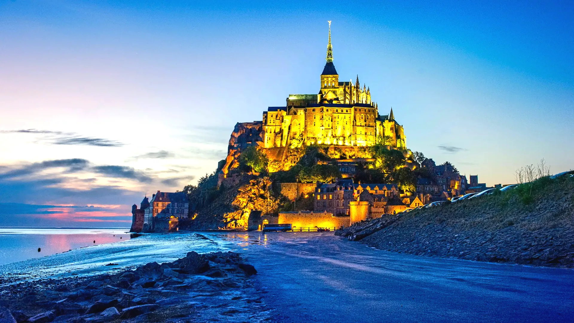
The tides are the reason Mont-Saint-Michel looks the way it does. Twice every roughly 24 hours, the sea in the bay retreats kilometres from the rock and then returns, with one of the largest tidal ranges in continental Europe — up to about 14 metres on the highest days. The bay floor empties to a vast sandflat at low water and refills as the tide rolls in across the polders. The interaction between this natural rhythm and the man-made approach to the rock has changed dramatically over the past 150 years. In 1879 a raised dyke was built to allow carriages and later cars to drive directly to the village; over time it silted up the bay and was choking the maritime character of the site. In July 2014 the dyke was replaced by a pile-supported causeway-bridge designed by Dietmar Feichtinger Architectes, which lets seawater pass underneath and is slowly restoring the bay's natural sediment cycle. This guide explains what the tides actually do, what a grande marée is, how the new bridge changes access, and the safe and unsafe ways to walk on the sand.
How the Bay of Mont-Saint-Michel actually works
The Bay of Mont-Saint-Michel is a shallow, funnel-shaped indentation in the Channel coast on the border between Normandy and Brittany. The shape of the coastline amplifies the incoming tide as the water squeezes into a narrowing basin, which is why the tidal range here is so much larger than elsewhere on the French Atlantic coast — roughly 14 metres at maximum against more typical Atlantic ranges of 4 to 8 metres. France's hydrographic service, the Service hydrographique et océanographique de la marine (SHOM), publishes the official tide predictions for the bay using the reference station at Saint-Malo, and the Mont-Saint-Michel tourist office at ot-montsaintmichel.com republishes them in a friendlier monthly format.
Twice every roughly 24 hours — the actual interval is closer to 12 hours and 25 minutes — the water cycles between low and high. At low tide, the bay floor is exposed for several kilometres around the Mont, and the rock stands in a vast plain of grey-and-gold sand with shallow river channels running through it. At high tide, the water reaches the foot of the ramparts and laps along the lower village walls. The visible front of the rising water is not literally galloping-horse fast — that is a poetic 19th-century description — but it moves at a brisk walking pace, which is fast enough to overtake a casual walker who has wandered too far out onto the sand without an awareness of the tide table. Always check the time of the next high water before stepping onto the bay floor.
Tidal coefficients and what a grande marée is
France uses a tidal coefficient system that runs from 20 (the weakest neap tide) to 120 (the strongest spring tide), with most ordinary tides falling between 40 and 80. A 'grande marée' is officially declared whenever the coefficient exceeds 90. The strongest of the year are tied to the equinoxes in March and September, when the gravitational alignment of sun and moon amplifies the range, and to the lunar phases of new and full moon throughout the year. SHOM publishes the precise annual calendar with dates and coefficients about a year in advance, and the official Mont-Saint-Michel grande-marée bulletin at montsaintmichel.gouv.fr relays the year's strongest windows for visitors.
Coefficients matter because they decide what the tide actually does at the Mont. At a coefficient of 90 to 100 you get a strong, photogenic high tide that reaches the lower village walls but does not flood the new causeway-bridge approaches. At 100 to 110 the water rises higher still — the most dramatic high-water photographs come from this band — but the bridge remains passable. At coefficients above roughly 110, the rare top-of-scale events, the water rises far enough to overtop the bridge approaches for one to two hours either side of peak high tide, briefly cutting the Mont off and returning it to true-island status. These events happen only a handful of times per year and are announced on the official tourist-office calendar weeks in advance.
The 2014 causeway-bridge: how it changed everything
In July 2014 the old 1879 dyke-road was replaced by a new pile-supported causeway-bridge designed by the Austrian-French architect Dietmar Feichtinger. The structure, formally 'La Jetée — Pont-Passerelle du Mont-Saint-Michel', sits on slim concrete piles and is built to let seawater pass underneath at every state of the tide. The change was the centrepiece of a much larger 'Rétablissement du caractère maritime du Mont-Saint-Michel' project — restoring the maritime character of the Mont — which also included a new Couesnon river barrage and the relocation of all visitor parking to a new mainland complex 2.5 km from the rock. The old dyke was demolished in stages.
The visible consequence is that access to the Mont is no longer cut off by ordinary high tides. Visitors can walk to the village along the dedicated pedestrian path on the bridge, or take the free Le Passeur shuttle bus, on essentially every day of the year. The invisible consequence is more interesting: with the dyke gone, seawater is once again sweeping sediment away from the foot of the rock, and the bay around the Mont is slowly returning to its medieval maritime character. The process takes decades and is still ongoing, monitored by the public authorities responsible for the site. Visitors who walked the old dyke before 2014 sometimes report that the rock now looks 'more like an island again' from the mainland — the new bridge is deliberately less visible from a distance than the old raised road.
When does the Mont actually become an island?
The Mont is briefly cut off only on the very highest tides — coefficients above roughly 110 — which means in practice a small number of windows each year. The exact dates and coefficients are published by SHOM about twelve months in advance and confirmed by the official tourist-office grande-marée bulletin closer to the day. The island-isolation lasts approximately one to two hours around peak high water, after which the receding tide reopens the bridge approaches. During the isolation window, pedestrian and shuttle access to the village is suspended for safety; visitors caught on the rock simply stay until the water withdraws.
Watching the Mont return to true-island status is one of the headline experiences the site offers. The best viewing position is the mainland Barrage du Couesnon and the upper terraces near the visitor centre, where you can see the water rise across the bay and then close the final gap to the bridge approaches. Plan to be in position about two hours before peak high tide on a grande-marée date. The official tourist office sets up dedicated viewing arrangements on the strongest days of the year and publishes the exact times of the day's high water so that you can pace your arrival. Photographers should bring a tripod, neutral-density filters for long-exposure water shots, and a warm layer — the bay is exposed to the wind even on summer days.
Walking on the sand: safe vs. unsafe
Walking out onto the bay sand is one of the most extraordinary experiences the Mont offers — and one of the most dangerous if attempted alone. The bay floor is laced with quicksand pockets ('sables mouvants' or 'lises'), the tide rises faster than most casual walkers expect, and sea fog can drop visibility to a few metres within minutes. Every year unguided walkers have to be rescued from the bay; some do not survive. Official signage at the visitor centre and the village gate warns visitors strongly against venturing onto the sand without a state-certified guide, and the prefecture of the Manche département maintains a registered list of licensed guiding cooperatives.
Bay-walking guides are licensed under a competence-certificate system and are typically based in the villages around the bay — Genêts on the south Brittany shore, Beauvoir or Le Mont-Saint-Michel itself, Saint-Léonard, Vains. Walks range from short 2-hour quicksand-discovery loops near the rock to the classic 12–13 km traverse from Genêts to the Mont, which crosses the Couesnon and Sée river channels and takes most of a tidal cycle. Bring closed shoes you can rinse afterwards, shorts or rolled-up trousers, water and a sun hat; you will get wet up to the knees and muddy up to the elbow. Booking is direct with each cooperative (Chemins de la Baie at Genêts is the largest), and tours run only when the tide schedule allows, which means meeting times shift by several hours day to day. Bay walking is one of those experiences that visitors who do it remember for decades — but only with a guide.
Frequently asked
How big is the tidal range at Mont-Saint-Michel?
Up to roughly 14 metres on the highest spring tides — one of the largest tidal ranges in continental Europe. Most ordinary tides are in the 6 to 10 metre range.
Is the water really fast?
Fast enough to overtake a casual walker who has wandered onto the sand without checking the tide table. The 'galloping horse' description is poetic; the actual visible front of the rising water moves at a brisk walking pace, which is still hazardous if you misjudge the timing.
Does the tide ever cut off the Mont?
Only on the very highest grandes marées — coefficients above roughly 110 — which produce island-isolation events lasting one to two hours. These happen only a handful of times per year and are announced in advance by the official tourist office.
What was the old dyke and why was it replaced?
The 1879 raised dyke-road allowed direct vehicle access to the Mont but silted up the bay over a century, gradually choking its maritime character. It was replaced in 2014 by the pile-supported causeway-bridge, which lets seawater pass underneath and is restoring the bay's sediment cycle.
Can I drive onto the Mont?
No. All visitor parking is at the mainland 'Parking du Mont-Saint-Michel' about 2.5 km from the rock. Access to the village is on foot along the bridge's pedestrian path or by the free Le Passeur shuttle bus.
Where do I find the official tide schedule?
SHOM (shom.fr) publishes the official predictions for the bay using the Saint-Malo reference station. The Mont-Saint-Michel tourist office at ot-montsaintmichel.com/marees republishes them in a friendlier monthly format with coefficients.
What are the strongest tide windows in 2026?
The strongest coefficients of the year are tied to the equinoxes in March and September, with secondary peaks in April and October. Consult the SHOM annual calendar and the montsaintmichel.gouv.fr grande-marée bulletin for the precise dates and coefficients.
Can I walk on the sand around the ramparts on my own?
Walking briefly on the firm sand at the foot of the lower ramparts close to the village is widely done, but venturing further out — across the open bay floor — is genuinely dangerous and should only ever be done with a state-certified guide. Quicksand pockets and the speed of the rising tide make unguided walks a real risk to life.
Where do I book a bay walk?
Directly with one of the licensed guiding cooperatives — Chemins de la Baie at Genêts is the largest, and several smaller operators run from Beauvoir, Saint-Léonard and Vains. Meeting times are set day by day around the tide schedule.
Is the bay walk suitable for children?
Family-oriented short walks (typically 2 hours, close to the rock, mild quicksand demonstration) are run by several licensed cooperatives and are appropriate for children from around age 6 upward depending on the operator. The full Genêts-to-Mont traverse is a long day for adults and not suitable for young children.